STORM SCOUTGulf & Atlantic Storm Tracker
Loading…
Loading…
Systems live
My threat level
Alerts (my area)
7-day rain
Season progress

🗺️ Live Map

Storm positions update automatically from the National Hurricane Center. Toggle live radar to see rain and storms right now.
Layers:
Depression / Disturbance Tropical Storm Hurricane Forecast path Cone Disturbance (% = odds it becomes a storm)

🌊 Flood Watch

Live river levels near your selected location, from NOAA and USGS gauges — the same instruments emergency managers watch. Flooding kills more people in the US than any other weather hazard.
Finding rivers near you…

🚗 Turn Around, Don't Drown

  • 6 inches of moving water knocks an adult off their feet.
  • 12 inches floats most cars. 18–24 inches carries away trucks and SUVs.
  • More than half of flood deaths happen in vehicles. If water covers the road, you cannot know how deep it is or if the road is even still there. Turn around.

🌙 Why flash floods kill at night

Most flash-flood deaths happen in the dark — rain falls upstream, the river rises hours later downstream while people sleep. That's why the gauges above matter: a rising river upstream of you is the warning, even under clear skies. If you live near a creek or river, enable emergency alerts on your phone and know your route to high ground.

📖 How to read a river gauge

  • Stage = how high the water is right now, in feet.
  • Action stage 🟡 = getting interesting, officials start watching.
  • Minor 🟠 / Moderate 🔴 / Major 🟣 flood stage = water leaves the banks — minor means low spots flood, major means neighborhoods do.
  • The bar on each gauge card shows how close the river is to flood stage.

🌀 Active Storms

Every storm the National Hurricane Center is tracking right now — explained so anyone can understand it.
Loading storms…

🔭 Where Could the Next Storm Form?

The official 7-day outlook. Shaded areas = spots forecasters are watching. An X or a high percentage means "keep an eye on this one."
NHC 7-day Atlantic tropical weather outlook map
Atlantic & Gulf — 7-day formation outlook (National Hurricane Center). Yellow = low chance, orange = medium, red = high chance a storm forms there.

🤖 Scout AI Briefing

Scout reads every live feed — storm positions, motion, alerts, and rainfall — and writes you a personal forecaster's briefing for your selected location. Updates automatically.
Threat level for
Calculating…

📝 Today's briefing

Reading the feeds…

📚 History rhymes: storms like today's

A real forecasting tactic called "analog matching" — Scout compares today's setup (month, location, strength) against a century of hurricane history.

🧪 Forecast Models & Season Outlook

The pros' guess vs. what's actually happening — models, this year's names, and the forces that make or break hurricanes.

📊 The 2026 season scorecard — forecast vs. reality

8–14
Named storms predicted
3–6
Hurricanes predicted
1–3
Majors (Cat 3+) predicted
Atlantic systems live now
NOAA's call (May 2026): 55% chance of a below-normal season. The big reason: an El Niño is developing — the Atlantic's natural storm brake (explained below). But the Atlantic is warmer than normal, so the storms that DO form still have plenty of fuel. Translation: fewer storms likely, but never zero risk — it only takes one.

🛰️ Live satellite — the storm's-eye view

Fresh GOES satellite imagery of the US and nearby waters. Bright white spirals over warm water = trouble. Updates every few minutes.
Live GOES satellite image
Source: NOAA GOES-East · full imagery site · Hurricane Hunter recon data

🌬️ Live forecast model — interactive (Windy)

Drag, zoom, and press play to watch the wind forecast animate. Swirls = storms. This is the same ECMWF "Euro model" the pros use.

⛽ What FUELS hurricanes

  • Hot ocean water (80°F+) — a hurricane's gasoline. The warmer and deeper the warm water, the stronger a storm can get.
  • La Niña — cool Pacific water that calms the upper winds over the Atlantic, letting storms stack up tall and spin freely.
  • Moist, calm air — storms breathe humid air. A moist Atlantic with light upper winds is hurricane paradise.

🛑 What STOPS hurricanes

  • Saharan dust (the "sand storms") — giant plumes of dry desert dust blow off Africa all summer. That dry, dusty air chokes storms before they can breathe. Big dust outbreak = quiet tropics for a week or two.
  • El Niño — warm Pacific water that cranks up high-altitude winds over the Atlantic. Those winds shear the tops off developing storms like a lawnmower. This is what's developing in 2026 — the main reason NOAA expects a quieter season.
  • Wind shear & dry air — any strong change in wind with height tilts and tears a storm apart.

📛 2026 Atlantic storm names

Storms get named in this order once winds hit 39 mph. Names glowing blue are active RIGHT NOW. (Fun fact: this list repeats every 6 years — "Leah" is new, replacing retired "Laura" from 2020.)

📅 When & where hurricanes usually strike
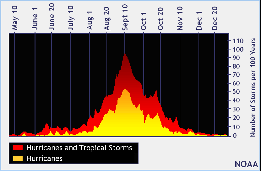
100+ years of history says the season has a rhythm. The peak is September 10.
NOAA graph of hurricane season climatology peaking September 10
Official NOAA history: storm activity by calendar day. The mountain peaks Sept 10.
Jun–JulEarly season — storms form close to home: the Gulf, Caribbean, and off the Southeast coast. Usually weaker, but short warning time.
Aug–SepPrime time — "Cape Verde" storms roll off Africa and cross the whole Atlantic. These become the big, powerful hurricanes with days of warning.
Oct–NovLate season — action shifts back to the Caribbean and Gulf. Florida is historically the #1 late-season target.
Reading the guesstimate vs. reality: the scorecard up top shows what forecasters predicted; the Live Map and Active Storms tabs show what's actually out there. When a storm exists, the cone + model spaghetti (links above) are your "possible turns" — bunched noodles mean confidence, scattered noodles mean watch closely.

📍 Storms & Alerts in My Area

Storm Scout finds your city automatically (or pick one below), then shows every storm tracking near you plus official National Weather Service warnings — translated into plain English.
Pick your coast, then your city · 🔴 = storm heading that way · 🟠 = storm nearby
Pick a location above…

☀️ Daily Weather & 7-Day Outlook

Today's conditions and the week ahead for your selected location.
Loading current conditions…

🌧️ Rain & flood outlook

Loading rainfall forecast…

🔮 Extended outlook — the next 14 days

Scout blends long-range wind, rain, and offshore wave forecasts into one daily "storm signal." Days 1–7 are solid forecasts; days 8–14 are trends — treat them as a heads-up, not a promise.

🌍 Entire Gulf & Atlantic — worst signal anywhere, each day

Sweeping the basin…

📍 Your area

Loading extended outlook…
Signal blend: wind gusts + rainfall + offshore wave height (nearest sea point) + rain probability · Source: Open-Meteo ECMWF/GFS ensemble & Marine models

✅ Prepare & Recover

Scout AI matches this checklist to the actual storm timeline for your location. Check items off as you go (resets when you reopen the app).
Reading the storm timeline…

Your checklist

🗺️ Know your evacuation zone

The #1 thing to do BEFORE a storm exists. Look up your zone now and write it down:

Rule of thumb: you run from water (surge zones), you hide from wind. If your zone is called, go — even for a "weak" storm.

🏚️ After the storm

  • Apply for help: DisasterAssistance.gov (FEMA) — apply early, even if unsure you qualify.
  • Power outages: PowerOutage.us tracks restoration by county.
  • Find open shelters: Red Cross shelter map, or text SHELTER + your ZIP to 43362.
  • Generator safety: outdoors only, 20+ ft from windows. Carbon monoxide kills more people after storms than the storm itself.

👨‍👩‍👧 Family check-in

Cell networks jam after a storm — texts get through when calls don't. Tap to copy a ready-made check-in message:

🚒 Ops Mode — Emergency Management View

Decision support for responders, EOC planners, and serious preparers. Not a replacement for official NWS products or orders — always follow your agency's direction.

⏱️ Operational window

Calculating…

🗂️ State alert board

Loading statewide alerts…

📋 Decision-point timeline

📠 Situation report

One tap compiles storms, alerts, arrival timing, and rainfall into a formatted SITREP — ready to paste into email, WebEOC, or a briefing.

🎓 Learn the Lingo (No Meteorology Degree Needed)

The stuff "nobody knows how to read" — decoded.

💨 Hurricane categories, translated

TDDepression — under 39 mph. A baby storm. Mostly a rain problem.
TSTropical Storm — 39–73 mph. Gets a name. Downed branches, power flickers, flooding.
Cat 174–95 mph. Damaged roofs and trees, power outages for days.
Cat 296–110 mph. Major roof/siding damage, near-total power loss.
Cat 3111–129 mph. "Major" starts here. Serious structural damage.
Cat 4130–156 mph. Catastrophic. Areas unlivable for weeks.
Cat 5157+ mph. Total devastation. Leave if told to. Period.

🍦 What's "the cone"?

That white cone on forecast maps shows where the center of the storm will probably go over 5 days. Two things everyone gets wrong:

  • The storm is bigger than the line. Rain, wind, and flooding reach far outside the cone — being "outside the cone" does NOT mean you're safe.
  • 1 in 3 storms leaves the cone. It's a best estimate, not a promise.

🍝 Spaghetti models, explained

Each "noodle" is one computer model's guess at the storm's path. How to read them like a pro:

  • Noodles bunched together = forecasters are confident. Trust the cone.
  • Noodles spread everywhere = high uncertainty. Anyone in the spread should pay attention.
  • Ignore any single wild noodle — it's the cluster that matters.

⚠️ Watch vs. Warning

The most confusing pair in weather:

  • WATCH = ingredients are there. "Conditions are possible." Get ready, review your plan.
  • WARNING = it's happening or about to. "Take action now." Act immediately.

Memory trick: a watch means watch closely; a warning means you've been warned.

🌊 Storm surge — the #1 killer

Surge is ocean water pushed inland by the wind — not rain. It's the deadliest part of a hurricane and the reason evacuation zones exist. If officials say your zone should leave, the wind category doesn't matter: you run from water, you hide from wind.

🔗 Go deeper (the pros' favorites)

Sites the hurricane-obsessed check every day:

🌀 Keep Storm Scout one tap away

Add it to your home screen like an app — free, no app store, opens instantly when the weather turns.

📲 Add Storm Scout to your iPhone

  1. Tap the Share button at the bottom of Safari (the square with the ↑ arrow).
  2. Scroll down and tap "Add to Home Screen."
  3. Tap Add — done! The Storm Scout icon is now on your home screen.

Using Chrome on iPhone? Tap the Share icon in the address bar instead — same steps.
